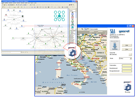
GEOREF is the new revolutionary software product to show i2 Analyst's Notebook entities on a Geographic Information System (GIS).
GEOREF implements a new, unique, method to exploit i2 Power2 semantic types. With a simple drag & drop you can transfer your entities, with geographic semantic tags, from an Analyst's Notebook Chart directly to a map.

Any entity with semantic types representing geographic information can be used.
GEOREF provides all the functionality to geocode the addresses (semantic tags) and to represent entities onto a map. All operations are completely automated and very user friendly. Nothing to learn. Nothing to configure.
Features
- Unique drag & drop semantic information transfer
- Easy to use
- Fully integrated with i2 Analyst's Notebook
- Complete compatibility with i2 Power2 Semantic Types
- Integrated geocoding support
- Fully internationalizable and customizable
at the moment it is available in English and Italian language
GEOREF works with Microsoft™ Map Point™ and MapInfo™ MapXtreme™ GIS. It can be integrated also with other GIS.
System Requirements
- O.S. Windows 2000/XP
- i2 Analyst's Notebook version 6.0.55
- GIS: Microsoft™ Map Point™ 2006 or
MapInfo™ MapXtreme